


vtt

HG74250
User
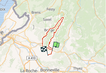

Length
43 km

Max alt
992 m

Uphill gradient
923 m
Km-Effort
55 km

Min alt
597 m

Downhill gradient
891 m
Boucle
No
Creation date :
2020-10-17 06:37:36.643
Updated on :
2020-10-21 16:32:22.134
3h45
Difficulty : Difficult

FREE GPS app for hiking
 SityTrail
IGN / Geographical institutes
SityTrail Plus
The world is yours!
About
Trail Mountain bike of 43 km to be discovered at Auvergne-Rhône-Alpes, Upper Savoy, La Tour. This trail is proposed by HG74250.
Positioning
Country:
France
Region :
Auvergne-Rhône-Alpes
Department/Province :
Upper Savoy
Municipality :
La Tour
Location:
Unknown
Start:(Dec)
Start:(UTM)
300708 ; 5112742 (32T) N.
Comments